
I had never been to Acadia. In 1996 I started up there for a weekend and one of the cylinders in my car went out, so I turned around about an hour into the trip. There was another time I was in Maine where the weather was bad a weekend I thought about going. So, it has always been in the back of my mind since. I have a friend, Ray Douglas, who went on a great trip to hike in Wales with me in 2018, and he goes to Acadia almost every year.
So, I had a week in September free because of staffing issues at the office, and I wasn’t feeling traveling by air anywhere due to all the trouble with airports and lost bags, especially going to Europe. So, maybe a road trip to Acadia would be workable. Once I decided on a hotel in Bar Harbor, I worked on the rest. Since I was driving up through Connecticut, it gave me a chance to see my friend, Rayna Fisher McLaughlin, whom I haven’t seen for 4 or 5 years, and who got married this year. I got that arranged, then set up a night’s stay at my sister, Jennifer’s, in Framingham, MA.
Getting there: I left on Saturday morning, the 10th, and made it to Old Saybrook a little after 1. Rayna and I had a nice lunch at a good restaurant and then walked around the historic area where there were remnants of a fort. I was right on time at Jennifer’s, and she made a nice meal of cauliflower gnocchi and a dark chocolate dessert. Shaun, her husband of nearly 34 years, has set up a porch man cave with three TVs, and we watched the US Open tennis and college football until bedtime.
I did a 4.5 mile run Sunday and then left. The plan in my head was to drive to Portland, where I had only been briefly twice before, to get lunch somewhere, then to take the coastal route, Rt. 1. I found my way to the downtown and waterfront area of Portland. It is free to park on the street there Sundays, so I did, and I walked around for about 90 minutes, during which I also had a nice lunch at the bar of a place I have since forgotten. It was good, especially the local ginger beer.
I got back in the car and found Rt 1. It was a nice route, going through a bunch of small towns, including Freeport, the home of L.L. Bean and the location of many tourists. I didn’t stop, but looked around in Rockport (pretty, especially the hotel over the harbor), Thomaston and Camden (nice old homes). I arrived in Belfast, ME just before 4pm. I had a nice hotel room with a deck within sight of the sea. It was about $90 less to stay there than Bar Harbor and I could still drive in from there Monday morning for a long hike before checkin. I had a big dinner at a local restaurant and a good night’s sleep. I ran back into Belfast on the main road Monday morning, which was good enough.
ACADIA
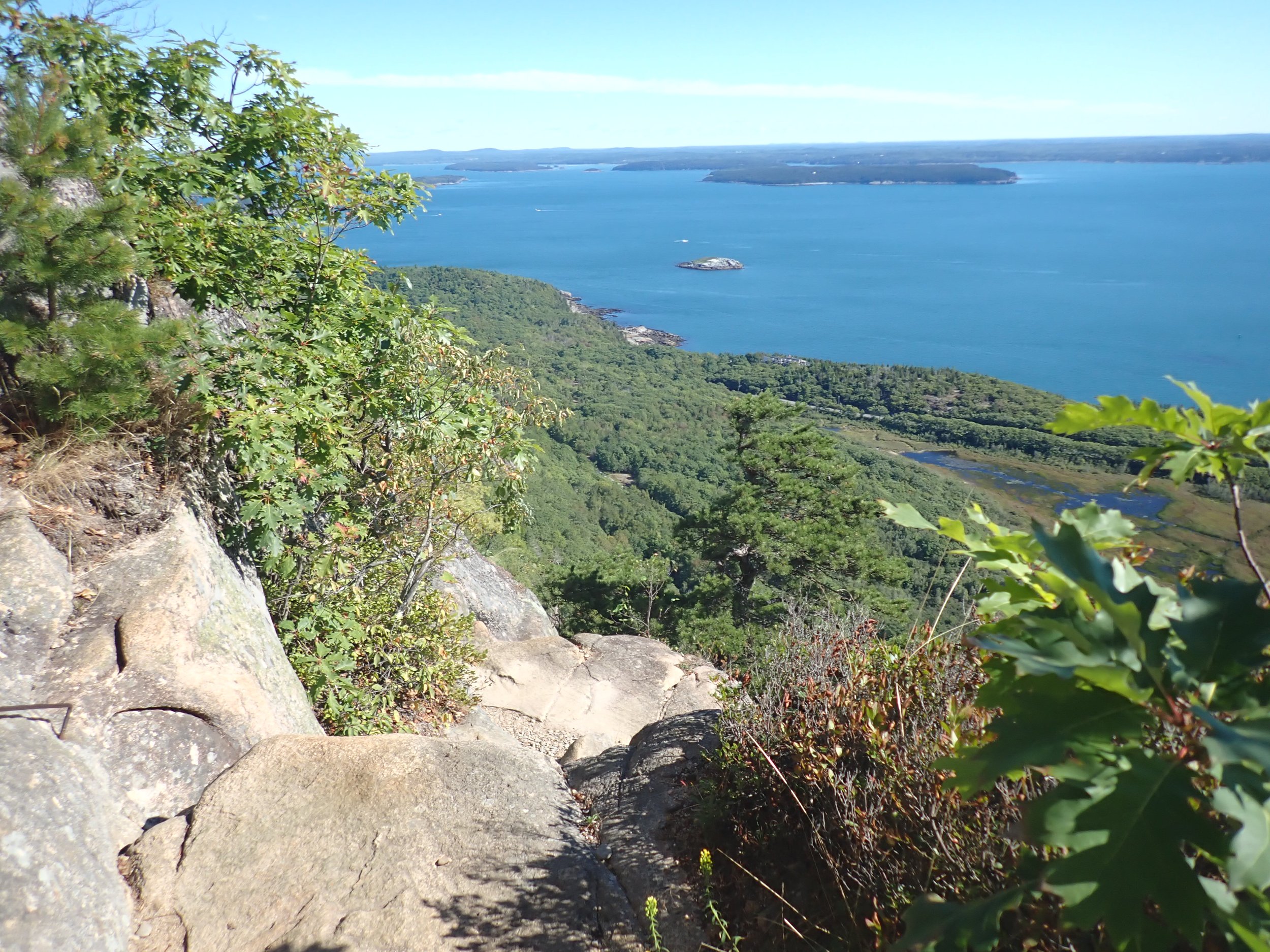
This national park deserves its reputation as a hiking mecca. There are over 100 miles of trails for cycling and hiking, and some of them are quite challenging. I have hiked all over the world, and have been in some of the most scenic places. Acadia is certainly nice, with views of islands and shorelines, but it doesn’t come close to a place like Yosemite, not even to a run of the mill area in New Zealand. Its trails, however, are rugged. There are few “normal” trails, where animals may have walked over the centuries and then humans have cleared brush and removed rocks, creating an easy to follow path. There are also few switchbacks to get up the steeps. At Acadia, the trails climb up the rockfalls created by gravity over centuries. A day of hiking is spent scrambling, crawling, and stepping over rocks, boulders, and roots, both up and down. The trail map I bought at the visitor center helpfully includes the percent grades along the routes. The easier ones are 10% or so, with the 20+% rough.
In addition to being rough and rocky, the trails were poorly marked. The “blazes” were small 2x3 inch blue marks on rocks and slightly bigger blue boxes on an occasional tree. On the large, bare rock areas, of which there were many, there were cairns to help some. At trail junctions, there were small wooden poles with directional signs often very hard to read. The poor markings and rugged routes made it slow going most of the time.
It was not that crowded. Most of the trails were easy to pass people on. The weather was good. Monday and Wednesday were warm and sunny, near 80 degrees. Tuesday rain was called for in the afternoon, but I was able to get the hike in before it started. You did not want to be going up and down on granite that was wet. Thursday and Friday were cooler and sunny, with a brisk wind.
The Bard of Acadia: I managed to do a lot of hiking by myself. I would catch up to people and occasionally utter a witticism or two. The best: I was really moving on a long hike on Wednesday when I caught up to a group of three men and three women walking in single file with the men at the rear. The last man in the group let me by, and the other men did as well, but the women were oblivious. I continued behind the last woman, and she started to take off one of her shirts while she was walking. Finally, one of the guys called to her, saying her name and that there was a man behind her trying to get through. She was completely surprised, so I looked back at the the men and said, loud enough for all to hear: “Women are always the last to notice a strange man following them.” They all laughed, and the woman in front of me said, “Maybe we want a strange man to follow us.” The man who had let me through said, “You have 4 strange men following you.” it was pretty funny. Another: on an uphill trail on Monday, I caught up to a man and two women. The women were talking loudly about something. He was following them and told them to stop and let me by. The loudest woman said, obviously, “You are going faster than we are. “ I said, “Well, I am not talking to anyone, so it is easier.” They all laughed, and the guy said, “I’m not talking to anyone and it’s not easy.” I said, “Someone has to listen.” Finally, I was coming down a rocky part when two women walked up. They were griping about the trail, and one said she couldn’t guess how much longer it was since the trails were so rough. It could take much longer than it should. I said, “Are you talking about Acadia math?” They looked a bit quizzical. I said, “The trails are so rough you can’t really guess how long they will take. I planned a three hour hike yesterday and it took 6 hours.” They laughed and agreed. “Acadia math. That is right.”
Bar Harbor
Bar Harbor is a cute little town. I stayed at the Port Inn in one corner. It was about a half mile walk to the restaurants and waterfront. There were quite a few restaurants, but many of them were booked in advance, and all of them were expensive. None of my meals was great, but the best was a seafood risotto, which had the only lobster I ate. I had seafood almost every night, but mostly crab. The running was nice, but all the paths only went so far. The first day I had the enjoyable discovery of a tidal path to the Bar Island just off the shore that is accessible at low tide. I ran across and around the trails on the island at the end of the run. There are lots of lovely old houses serving as inns and BnBs.
Getting around
The roads around the park are very confusing. Thank goodness for google maps - it got me most of the places, though the first day, I asked for “Echo Lake Parking area” and it gave me directions to Echo Lake in California. The absurdity made me laugh out loud when it warned that at several times I would have to cross into Canada and back!!! On Friday I got on the wrong road and had no idea. I finally pulled over and looked a the map and realized there were no directions to get to where I wanted to go. Most of the parking areas had no signs. So I was pleased to take advantage of the Island Adventures Shuttle, which ran out of the visitor center and the village green in Bar Harbor.. The good: no worries about parking; nice drivers with good info (usually); go to almost anywhere useful. The bad: don’t start until 9am; often run late; routes can take 90 minutes to get back to town. Wednesday it got me right where I needed to go, but for the return trip I couldn’t find the stop, and then the bus was over 15 minutes late, so I took a different one, and the bus I needed came right behind it. The bus I was on had one of those 90 minute routes, so I got off at the next stop and waited for another bus. I was eaten up by mosquitoes, getting 6 or 7 bites in less than 10 minutes, then got on another bus that went to the beach and back in 40 minutes. So, it took me almost 90 minutes to get back to the Village Green from a point just 5 minutes away. On Thursday it worked much better.
The Hikes:
Day 1: I drove from Belfast to the Acadia Visitor Center, which took about 90 minutes. The parking lot there is smaller than it should be considering a lot of people park there to catch the shuttles. I found one of the few spots, went to the bathroom and to the information counter. After a short wait I talked with an elderly lady. I told her I wanted to do the hardest routes, but I knew some would be crowded. She kept asking me what I was up for, and I finally said, “I could climb Mt. Everest today if I had to, so whatever is hard here.” She ended up giving me great advice. I got the best trail map that was water and tear resistant and left. After getting the GPS sorted, I had no trouble getting there, and there were so many parking spots I thought I was in the wrong place. It was Echo Lake, which is one of the few lakes or ponds one can swim in there, as many are used for drinking water. There was a man using the bathroom while carrying around a screaming toddler. Sigh. I started right out on one of the toughest routes, the Beech Cliffs Trail (anything with “Cliffs” in the name at Acadia is going to be tough and likely have some metal rungs and ladders on it). I was introduced quickly to the rocky paths and was out there pretty much alone. The ladders were easy, though they are not as easy to get off, usually only going as high as the cliff. I got to the top quickly and then went on some side trails that eventually got me to the fire station at the top, with some OK views. From there I went down the other side and around another pond, eventually climbing back up via a different route and missing a turn, arriving back at the top of the Beech Cliffs. I got back on the trail I’d just done and found the connector and got down to the parking lot about 4-4.5 hours later. It was a good introduction to the area without dealing with crowds.


Day 2: I thought about trying the shuttle, but I thought it would be better in the end to drive to give me more flexibility about getting back if the weather got bad. I drove to the Bubbles Parking lot, and I got the last spot there (!!). The Bubbles are a pair of smaller peaks close to Jordan Pond. I went up the South Bubble just a few minutes after getting there, and then went down the “Divide.” Mistake. It was very steep and rocky and hard on my knees, but I eventually made it (I took it upon myself to dissuade as many people as possible from going up it). I met more people walking around Jordan Pond, which is one of the easier hikes, and then decided to try Sargent Mt. The trail there was much like the Divide: very rocky and steep. I made it up to the areas of bare granite so common in Acadia, and, just as I did, clouds drifted in and took away most of the visibility. It got windy as well. I went a little farther but then thought the better of it and went back down. I did not want to try to go down those rocks if they were wet. I missed the peak and a possibly easier route down by not going on. I thought I might call it a day and head back, but then I saw the signs for Penobscot Mt and went up that. My calf started to hurt then and I turned around, but it started to feel better, so I went on up it. There I saw the first of many unleashed dogs (clearly states everywhere dogs must be on a close leash) for the week and evidence of “Bros.” But it was also socked it with clouds. After that ascent and descent, I was feeling a little tired, so I took what I thought was an easy trail across the ridge. I had made another wrong turn, though, and had gotten on the Jordan Cliffs trail. Mistake #2 that day. It was being worked on, so I passed a few workers, and then saw a sign about danger, cliffs, etc. I wasn’t going back past those guys, so I went ahead. It would not be that hard coming from the other direction, but the way I did it had me going down all the ladders and steep parts, all of them blind and hard to get down to. I was frazzled at times, but I kept going and got past the worst of it when I came on a nice young couple. He was helping her over an obstacle, and after she got over it, we talked a bit. She was a beautiful young woman, and I warned them of what was to come, and then we parted ways. There were some tricky parts, but it wasn’t as bad. I warned all the folks coming the other way how difficult it was and then found what I thought was another connector around a lake. Of course, I was wrong again, but I figured it out, went back down to Jordan Pond and around the other side and took the easier trail to the parking lot. This day was also between 4 and 4.5 hours of hiking and it was pretty challenging overall.


Day 3: I thought I might do an easier hike that didn’t take as long. At least that was the plan, but Acadia math took over once I started. I did take the shuttle from the Village Green, which was a half mile walk from my hotel room. Mostly old people there, but it got me right to the trail head. I didn’t want to go up Cadiullac Mountain in the morning, so I took the easier looking Kebo Trail to the Gorge trail, and these were both nice, normal hiking trails that were relatively flat with good footing. There was an old man with a white beard running on the Gorge Trail and as he approached, I said, “This looks like one of the few trails that would be nice to run.” He gruffly agreed and snorted past. I wanted to make my way to the Ladder Trail, which had a reported 41% grade, so I went down the Hemlock Trail, which was rocky but not steep, to the Jesup and then on that past the Sieur de Mont area. It was a nice, touristy area with gardens and some buildings to tour. The trails around it were all easy. I got to the Vann Trail, which went on one side of a pond, and it turned into yet another rock scramble/bouldering path that was very hard to follow (It was, in fact, completely unmarked). I was unsure at one point and started looking for markers when a man walked up. I asked him if I was on the trail, and, without stopping, he assured me I was and kept going at a rapid pace. I did not try to, but he would have been a challenge to keep up with. Eventually I got to the intersection with the Ladder Trail, which had the usual warning signs, and I started up. It wasn’t bad at all until it was. Narrow, steep rock stairs - i could easily touch the steps in front of my chest as my feel climbed the ones below most of the time. No one was there, and I got used to the exertion and kept moving with occasional few second breaks to catch my breath. I finally caught an older man who climbed off the trail to lie on a rock and rest. I saw a few people coming down, which would not have been fun. From the end of that there were bare rocks and scrambles up to the top of Dorr Mt. From there the view was ok, with Cadillac Mt., the highest peak in the park, to one side, and the water on the other. I vacillated a bit on what to do. It was already nearly 3 hours. I thought I could cross to Cadillac Mt and then go back to the parking lot in about 45 minutes (Acadia math - way off), and I thought that would be too easy. So I decided to go down Dorr Mt and catch another trail through the valley to Cadillac Mt and back, as the trail to get to the southern approach to Cadillac Mt was pretty rough looking. The path down Dorr Mt was lots of bare rocks, and it took much longer than I thought. The bottom was very rough and poorly marked, and I missed the turn to the valley trail. The trail I was on was disheartening. It seemed to go right up a dry waterfall - lots of steep bare granite, poor markings, very frustrating. I kept going and going, not aware even of what trail I was on. I still had hopes I was on the trail through the valley, but then I came to the Cadillac Mt. south trail. I still had a long way to go! But I ate some things then and it seemed to help, and I got a surge of energy as I started passing people. It wasn’t bad at all to get to the top. I took a few pictures and then started down. I passed a ranger talking to some folks, and then she caught up to me. I talked to her about the trail markings and how poor they were, and she agreed. She passed me, but then I realized I needed to rush to catch the 3pm bus. I was blowing down the rocky terrain and passed her again while she was talking to someone. I was surprised how long it took me even though I was going so quickly. I got to the road by the trailhead at about 3:05, when the bus should come. I knew I was supposed to walk farther to the next road and connector, but I was sure the bus should come by there, and I could wave it down. I turned left and went down the hill to the intersection, and still no bus. It was about 3:15 and I was getting riled up. I walked back up to the trailhead and , as I did, another shuttle went by for the loop road. I didn’t have time to think it out; I ran (literally) up to it as it stood idling and got on. I asked the driver a question about the sand beaches stop and he was unhelpful, so I sat down. Just as we pulled out the correct bus drove by us! Now it was ahead of us, so there was no way I could get on it. It went off on another turn and we went to Sieur de Mont, where I got off to wait for another option, since that bus would not get back to the village green for another 70 minutes. There was sign for the buses and none were coming for 30 minutes. So I paid a few dollars to go into the gardens and walk around. But then I saw a bench and decided to sit for a bit, since I hadn’t rested at all since getting off the bus at 9:05. Within two minutes I had several fresh mosquito bites, and then a bus pulled up. I ran out of the garden in time to see it pull away, but it wasn’t one I wanted. Obviously, the sign wasn’t correct, and 6 minutes and 5 more bites later, I saw another bus pull in. I took that one to sand beach and then a special bus came in right away to go back to the village green, but I still didn’t make it until almost 4:30!


Day 4: I thought I would be tired after that long hike, but I felt fine. I was worried about the Beehive, which was the hike I felt I should do. I’d heard it was very hard and scary. I didn’t want to be so tired I struggled on it. I got ready and took the shuttle to the Sand Beach stop, which was right across the road from the Beehive trailhead. I walked over and started up the trail. I was all alone. I was wondering still what to do when I got to the split in the trail where the easier way up is to the left and the Beehive to the right. There were a few people milling around, including some out of shape looking people who started up the Beehive. I said to myself, “Don’t be ridiculous - you will be in better shape and handle this better than anyone up there now.” I took a few steps to the trail and heard a woman to my left tell her friends she was going to do it and would meet them at the top. I waited for her and asked if she’d done it before, and she told me no. She looked in her 40s, with dark, tightly curly hair and a nice smile, fit, and I said to her, “Neither have I. Let’s do it together.” She agreed. So we chatted as we worked our way up the steep rocks to the cliffs. She was from Mechanicsburg, PA, and knew one of the doctors I’d worked with there long ago. We came to the first testy area and had to wait on a ledge. Finally we moved, but some brassy women caught up behind us. There were three women in front of us, two younger girls in their 20s, I would guess, and their mom in her 50s, with some gray hair. They were weak and over-matched. At the toughest spot, a ladder series, the brassy women started yelling at them to get out of the way and let us through, that they were holding everyone up. I didn’t think that was very nice, but they moved aside and I zipped up both ladders and around a few turns and we were at the top. I felt like Launcelot at the Bridge of Death after he answered the Keeper’s easy questions and was allowed to pass. I even said, like Sir Robin, “That’s easy!” My new friend and I found the Bowl trail and took it to where her friends were. We chatted briefly and I went on. From there I found my way to the top of Gorham Mt., which had some nice views and started down. At one junction I saw a sign for the Cadillac Cliffs trail. A woman was standing there and she said it was hard, with three ladders, and I would be going down the ladders if I went that way. I didn’t want another Jordan Cliffs experience, so I walked to the other end of what looked like a short trail (it wasn’t that short), and started back up it. It was a good test, lots of boulders and scrambling, but only three rungs, not three ladders. I met my two friends on that trail as well, with the pretty girl recognizing me right away (we actually met earlier that day as well, but not sure where - might have been on Gorham’s peak). We talked about the Jordan Cliffs and the Beehive, and they said the Precipice was much harder than the Beehive and just as scary. It was funny to see them again and to remember how beautiful she was. I pressed on and then did the same trail back to the bottom, where I found my way to the Ocean path and walked on that for a while until I came to a lovely set of boulders and rocks along the coast, the famous pink granite rocks. I went onto them and sat down to eat my lunch. It was the first time I sat down on any hike other than to slide on my butt for a few seconds. I got out an energy bar and started on it, keeping my eye on a seagull that was moving a bit closer every minute. I only lasted there long enough to eat that bar and take a few photos, and then I was on my way back to Sand Beach. It took a while, and then I crossed that, eating my energy bars as I walked, and did the trails on Great Head, which were surprisingly rough before crossing the beach and getting a bus to the Village Green. That day was 3.5 to 4 hours, but I was done and back early enough to walk around the business district, which is right next to the Village Green. I got two scoops of ice cream and then looked for souvenirs. I couldn’t find anything useful, but then I saw a bake shop on my way back and got a huge maple whoopie pie and a smoothie, which hit the spot after the ice cream.


Day 5: I had to pack up and leave after the last night in my hotel, and I wanted to be to the Precipice trail relatively early to try to beat the crowds but also parked in a place that made my exit as easy as possible. A little after 8am, I drove down the wrong road initially and had to back track and then get on the correct one (honestly, the lack of signs is terrible - it is like they don’t want people to know where to go). I found my goal: a parking lot along the main loop road outside the park from which I could access a trail that would take me to the trail head of the Precipice trail, the crown jewel of Acadia hiking and notorious all over. I had to walk maybe 200m on the side of the road, and there was not much traffic (all one way coming from behind me). I found the little trail I needed, poorly marked, and went down it. It looked like it might be a tough downhill at first, but it wasn’t, and the trail it connected with was very easy and right along a road. I finally came to the Precipice trail sign and went up that short trail to the parking lot. I was a little nervous, but bolstered by my confidence from the day before. There was no one around. I started up the trail, which is never easy. It has some tough boulders and rocks before you get to the cliffs. I started catching people then who were resting. A group of young people caught up while I was talking to two young women, but they did not want to go past me. I used that as motivation and did the rest of it very fast, with only a few short pauses to catch some breath. I got by a few more people, including an older guy who was elated at how much he loved the challenge. We took photos of each other before he let me go on. It is a much longer and harder hike than the Beehive and equally as dangerous, but I was soon at the top. I really didn’t have much trouble. You have to think a bit at every obstacle, but I never had any struggles or slips. The top was pretty and I took some photos there of a couple, and they of me, and then I headed down the trail that would take me back to my car. A younger woman caught me and walked with me, chatting about other hikes and eventually getting some stories from Africa out of me. We split up when I went to my car, and she walked back to the Precipice lot to meet her friends. The whole hike took a little over 2 hours. I saw her as I drove by. I was able to turn left before the entry points and drive back to town, past the visitor center and on the road.


The return trip was not bad. Lots of traffic the other way. This time I took interstates there and stopped to get some gas and had some snacks. I got to Jennifer’s about 5pm, and we ordered takeout from an El Salvadoran restaurant nearby (good). it was a quiet evening. I ran 5 miles in the morning and then headed off, stopping in Newport, RI, the first time I have been to that state. The city is pretty and has lovely coastal views, but it was super crowded for an auto show and bike race. I again ate snacks in the car and made it back to Bethlehem about 5pm. My little hybrid did great. I got close to 70mpg the whole trip up and around 63mpg on the way back (I drove faster and there were steady headwinds).
Trip Summary: Acadia is a rugged hiking destination in the Northeast, probably the only one like it on the east coast. It is fairly remote yet popular, but still has quiet areas and some decent scenery. I doubt I will go back, but the trip went well, and I got a lot done every day. I did all the hardest hikes with a certain elan that assured me I was not “losing it” after all these years of working out.